It is well known that countries have diverging views on what their borders ought to look like. However, while working on digital maps, it was surprising to me to see just how much of a global map is up to interpretation. In the following, let us look at some examples of maps that are drawn differently depending on who you ask and what the implications are for everyone working with maps.
This article is part of a series about map data. Part one can be found here.
I want to start with the disclaimer that I do not mean to endorse or condemn any particular geopolitical view. The role of the map maker is to record and make available any geographic information that is relevant to the use case at hand, irrespective of their own political opinions. Knowing that there exists a border at a given location that is recognized by one country but not by another could be relevant for a user of a map. Furthermore, as we will see, not complying with local regulations may render your map unusable for people in a particular jurisdiction because of political or legal risk.
Of course, the result can be used to carry a political message just like any other medium that describes the state of the world. I think that the act of gathering information and making it available should be decoupled from the use of said information.
Borders
The most well-known example of geopolitical interpretation is the shape of international borders: Which territory belongs to which country? Competing claims of multiple countries to the same geographic area are a common source of conflict. Sometimes, this is a consequence of traditional methods of defining borders. Natural landmarks are a typical case: If a border is demarcated by a river and that river changes course, should you consider the old or the new shape as the authoritative border geometry?
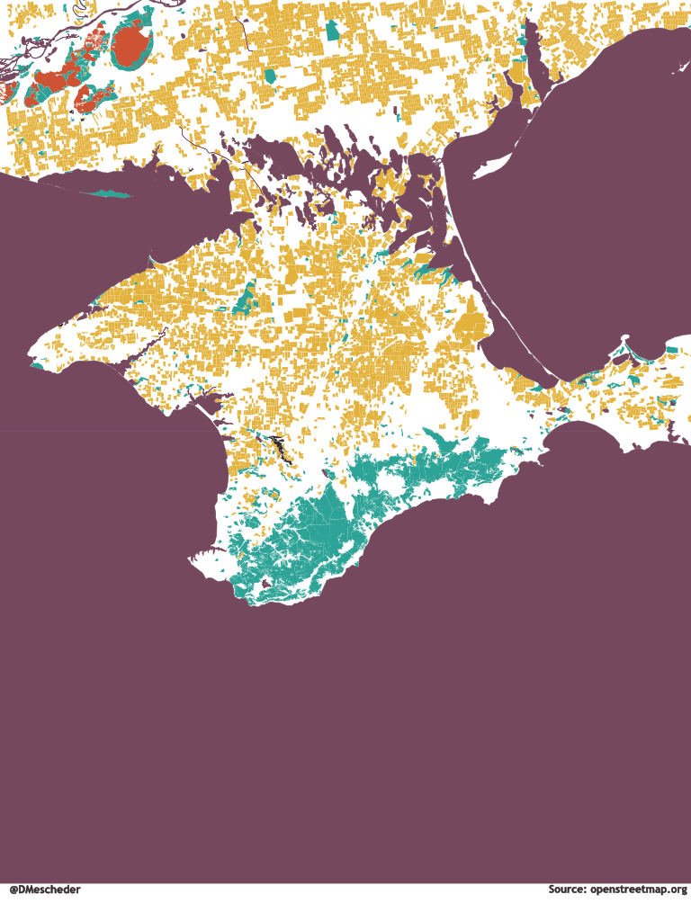
Sometimes, these situations are the results of armed conflict. The state of Kosovo is recognized by about half of the UN member states at the time of writing. Serbia considers this territory a part of its own borders. Since the annexation of the Crimean Peninsula in 2014, Russia considers this area part of its own territory. Many states do not recognize this claim even though, at the time of writing, Crimea is de-facto under Russian control.
To see what this means for the mapmaker, consider the case of the disputed Kashmir region between India, Pakistan, and China. The region has been the subject of a long-running dispute between these three countries with each claiming parts of that mountainous terrain. Here are three different images of the same zone, visualizing different interpretations of the situation:

For comparison, consider how Google Maps shows the area when browsing from my current location in Belgium, Europe:

The use of dashed lines is a common tool to avoid taking sides. Instead of saying “there is a border at this location”, the mapmaker expresses “there is at least one party that thinks there is a border here, and at least one other party that disputes this interpretation”.
This seems like a good compromise, however, it is not sufficient if you want people in India to use your map. The 2016 Geospatial Information Regulation Bill made it illegal to represent India on a map in a way that differs from the official guidelines. Violations can lead to fines or even prison time.
This is just one example of the legal risks that companies face when operating in a market with geopolitical sensitivities.
These laws are often still written with the traditional understanding of the word “map” as a paper document in mind. As discussed in my last article, the word has become broader since the advent of digital geospatial applications. It is less straightforward to translate these regulations to the digital space: Do they primarily relate to the display algorithm? Does it also extend to the information in the data? In other words, would a textual description of a polygon that does not include Jammu and Kashmir with a reference to the name “India” create a legal risk?
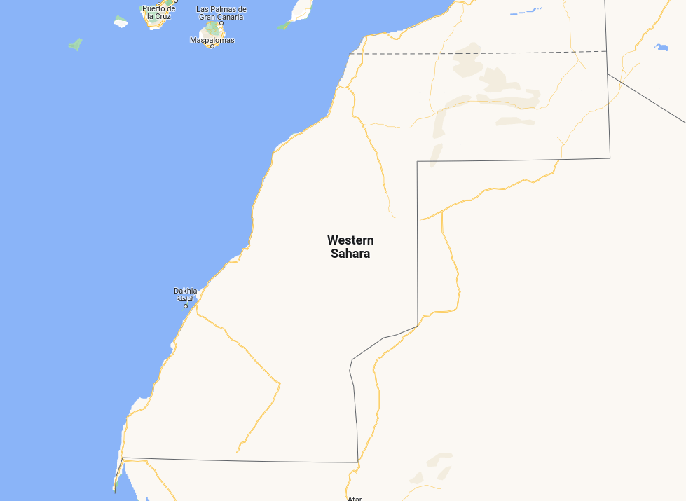
There are many examples of disputed territories around the world. The territory called Western Sahara, for example, is disputed between Morocco and the self-proclaimed Sahrawi Arab Democratic Republic. Morocco has de-facto control of a large portion of the territory. At the time of writing, the only other UN member state recognizing Morocco’s claim over the Western Sahara territory is the United States. As you can see below, Google Maps and OpenStreetMap made different choices when rendering this area:

Names
Place names and languages are further important sources of geopolitical interpretation. Consider for example the situation of the Falkland Islands, itself a disputed territory. Most of the world sees the Falkland Islands as a British overseas territory and calls the capital city “Port Stanley”. Argentina disagrees with this English name which contradicts their own claim. On an Argentinean map, the same city would carry the name “Puerto Argentino”. Note that this is not simply a Spanish exonym as a map made in Spain might instead print “Puerto Stanley” or simply “Stanley” at the same location.
A slightly different disagreement is the situation of the Persian- or Arabian Gulf. Iran and most of the world refer to this body of water as the Persian Gulf. However, a group of Arab states including Iraq, Saudi Arabia, Kuwait, Oman, Qatar, the United Arab Emirates, and Bahrain reject this naming and use the name Arabian Gulf instead.
A map sold in the Emirates would probably show the latter name. When navigating to the location in Google Maps from my current location in Belgium, the following is shown:

Visibly, Google decides to prioritize the internationally prevalent name and also shows the alternative label. This may not be sufficient for the nations favoring “Arabian Gulf” but it is maybe good enough for most European Google customers.
Status of Territories
Some areas of land are easy to call a country. Some other areas are more difficult to assess and sometimes it depends on the context.
Take Gaza as an example: The Israel-Palestine dispute has rendered many of the borders in this area extremely complicated. The areas, whose national color is disputed include the Westbank which since the six-day war of 1967 is considered a disputed territory of Israel by some. Others recognize the existence of a Palestinian state with territory in the West Bank. (As with other examples, this is an oversimplification of the situation. It is not possible to do justice to the complexity of this conflict in a blog post focused on map data.)
Where does that leave the Gaza Strip? Those that recognize the state of Palestine consider Gaza a part of that state. Israel, on the other hand, neither recognizes a Palestinian state nor does it claim the Gaza Strip as part of its own territory since its unilateral disengagement in 2005. Therefore, according to this view of the world, the Gaza Strip is not part of any sovereign state.
To model this view of the world, it would be necessary to include the concept of a territory or a region that exists and has a name but that does not have the status of a state.
The Gaza Strip is not the only place whose status is more complex than that of a traditional nation-state. Another example of this is Antarctica which is the subject of multiple competing territorial claims. However, not all of Antarctica is claimed by someone, and even though New Zealand claims a part of Antarctica, this claim is not typically shown on a map of the New Zealand state boundaries.
Capital Cities
Capital cities are typically marked as such on digital maps. Having the information on which city forms the administrative center of a country can, for instance, enable a natural rendering in which the capital’s locations are visible even on higher zoom levels.
Which city should be considered a country’s capital? This is certainly a problematic question in scenarios where the very existence of a country is disputed – an entity that is no country cannot have a capital. There are other examples, however: Take the state of Israel that considers Jerusalem, the seat of the Knesset, its capital city. Many countries of the international community do not recognize Jerusalem as the country’s capital to avoid the symbolism and instead consider Tel Aviv the administrative center. A notable exception is the USA which moved its embassy to Jerusalem in 2017.
Therefore, strictly speaking, when looking at a map you should get a different city highlighted as the country’s capital depending on whether you are based in the USA or Canada. However, showing Jerusalem as the capital to a user in a western country that does not recognize this status will likely carry a lower risk of a political backlash than doing the same in Egypt or Jordan.
Miscellaneous
We have seen that geopolitical sensitivities can relate to borders, capitals, and names. All of these have in common that they are concepts defined by people. What about geographic data which is less subject to interpretation? What about the actual physical shape of a landmass?
It turns out that even there, we cannot escape geopolitics: Apple reportedly gave in to a request of the Chinese government to magnify the scale of the uninhabited Senkaku/Diaoyu Islands which are the subject of a dispute between China and Japan.
Maps are an abstraction of reality and even seemingly objective facts tell a story that can conflict with a political narrative.
How OSM Handles Geopolitics
You might think that the best way of handling this complexity is to avoid taking a political stance. The mapmaker should be neutral, we should simply document what is known about the world.
The mapmaker might say: “there is a town here and according to Argentina it is called Puerto Argentino and according to the rest of the world it is called Port Stanley”.
We have already discussed the legal challenges with this approach. An additional complication is that maintaining this information is difficult. It is also not the approach the OpenStreetMap project has taken.
OSM relies on the “on the ground principle”. This principle dictates that the authoritative source of truth is what can be observed on the ground: If I have to go past an Indian border officer to enter a zone, then it is probably not a bad guess that I now find myself in India. This is compatible with the mindset of OSM, a map not composed by pulling together data sources from different archives but the work of an army of volunteers noting down their observations.
The principle is that I can go out, note that there is a street sign that says “Rue de la République” and then add to the OSM project the information that there is a street with that name at this location. I do not need to be concerned with the fact that someone in the village is of the opinion that it should actually be called “Bahnhofstraße”. The on-the-ground principle is an extension of this philosophy.
However, in many areas of the world, this theory is not so easy to follow. Furthermore, OpenStreetMap is a project composed of human beings with their own sets of values and opinions – aligning the views of different mapper communities is often not that simple.
Take for example the case of Crimea, an area that has been in the media since the events of 2014 and that, at the time of writing, sadly has again taken center stage of global consciousness because of the brutal Russian invasion in Ukraine.
At the time of writing, if you search for “Russia” on OpenStreetMap, the following will show up:

Searching for “Ukraine” provides the following result:

As you can see, Crimea is part of both country polygons. This is a result of a compromise after a difficult discussion that can be traced back on the OSM mailing list.
Having overlapping country definitions may be a way of compromising, a strategy that offends the least number of people. However, it also places the burden of resolving this ambiguity on the consumer of the data: Should I use a Ukrainian or a Russian postcode convention if I want a letter to arrive at a Crimean address? What political message do I send by displaying a map of Russia that includes Crimea?
Furthermore, “countries do not overlap” is likely an assumption that many engineers will implicitly make when processing map data. Handling these special cases will require accommodations in the software.
Naming disputes often result in multiple names being present on a given object. Here is the OSM definition of the Persian Gulf:
<relation id="9326283" visible="true" version="396" changeset="119434591" timestamp="2022-04-07T15:21:38Z" user="kiaraSh-Q" uid="2693232">
    <member type="way" ref="1049982429" role="outer"/>
    <!-- other members ... -->
    <tag k="name" v="الخليج العربي"/>
    <tag k="name:en" v="Persian Gulf"/>
    <tag k="alt_name:en" v="Arabian Gulf"/>
    <tag k="natural" v="bay"/>
    <tag k="type" v="multipolygon"/>
    <tag k="water" v="sea"/>
    <!-- other tags... -->
</relation>
Having both a name and an alt_name available is sufficient to allow users from all sides of the debate to find the object. However, this data does not detail which party recognizes which of the names making it more difficult for the consumer of the data to choose the most appropriate text to display.
Usually, the OSM community makes a choice for the default label that should be used if no other information about language preferences is present and sets the name tag accordingly. Interestingly, in this case, at the time of writing, the default label is the Arabic “الخليج العربي” for “Arabian Gulf”.
Conclusion
As with many things, mapmaking is more complicated than it first appears once you start looking at the details. We have seen different strategies for dealing with geopolitical interpretations: Aligning your map with one worldview, providing meta-information (“X thinks Y”), marking objects as disputed, or simply making a territory part of all claiming parties. None of the approaches is ideal in all circumstances.
We have also seen that geopolitical differences include more than just borders: Names and languages can be a sensitive topic and the political significance of places (“what is the capital of…”) has a political significance that cannot be ignored by map makers.
It is also worth noting that it is very hard to make a map that does not carry a political message of some form. Even if you mark a border as disputed you take a stance: “Side A does have a claim that we chose not to ignore…”
Geopolitical disputes are more common than you might think. Did you know that there is a disputed border between Germany and the Netherlands? Luckily, this particular dispute influences the relations between these two nations less than soccer-related rivalries, and in a Europe of open borders, these things matter less. Nevertheless, that does not mean that the map maker can ignore this ambiguity. To get a sense of the sheer quantity of disputes that there are, this online map of disputed territories is an interesting resource.
Working with data is always tricky. Most datasets, however, do not carry a risk of customs rejecting your merchandise at the border because the data does not say what the government wants it to say. This is just one more example that sets maps apart from other data sets.
Shout-Out
I want to give a shout-out to Jordi, whose Show&Tell presentation at RIAktr first got me curious about this topic and to the amazing team at TomTom working on geopolitical models. (You know who you are!)
